Montalban Ridge Overnight - 29-30/May/99
Here's a map of the trip.
It had been a while since I'd done a solo overnight and Memorial Day weekend just
seemed to work out right. Instead of the popular, usual places, I chose to explore
some of the Davis Path, the southern end of Montalban Ridge. I'd been up there
earlier in the spring, just up the Davis Path to Mt Crawford and Stairs. There are
designated campsites in the Dry River Wilderness area but I didn't know how far I'd
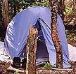
get or where I'd want to stay. So I packed up my small tent, stove, food, big camera,
and assorted gear and headed out.
 I started in at the trailhead around 9:30, a bit late but I didn't really have a
destination in mind. The trail starts on Rt 302 at an old and somewhat worn out
suspension bridge. But the trail starts climbing soon after
it enters the Wilderness
Area and it's a steady climb up to Mt Crawford. It was hot, and I was feeling the
fact that I hadn't done much to keep in shape for this kind of activity over the
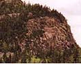
winter. I dropped pack at the spur to Mt Crawford and ran up there with a PowerBar and
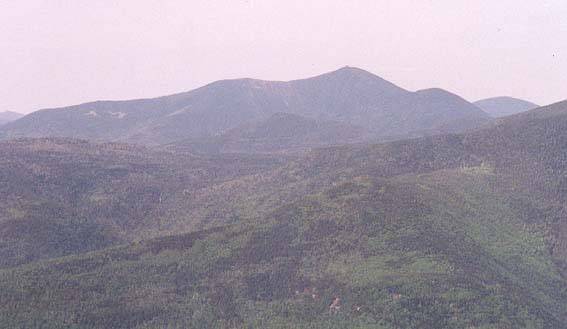
my camera. It is well worth the trip, as you get nearly 360 degree views, including one
of the best views of Crawford Notch in the mountains.
Washington was in the clear, and
you could follow Montalban Ridge the whole way up. It's really a nice mountain and for
only about an hours worth of work you are handsomely rewarded. You also get a nice
view of Stairs Mt, the next good view on the Davis Path.
I started in at the trailhead around 9:30, a bit late but I didn't really have a
destination in mind. The trail starts on Rt 302 at an old and somewhat worn out
suspension bridge. But the trail starts climbing soon after
it enters the Wilderness
Area and it's a steady climb up to Mt Crawford. It was hot, and I was feeling the
fact that I hadn't done much to keep in shape for this kind of activity over the
winter. I dropped pack at the spur to Mt Crawford and ran up there with a PowerBar and
my camera. It is well worth the trip, as you get nearly 360 degree views, including one
of the best views of Crawford Notch in the mountains.
Washington was in the clear, and
you could follow Montalban Ridge the whole way up. It's really a nice mountain and for
only about an hours worth of work you are handsomely rewarded. You also get a nice
view of Stairs Mt, the next good view on the Davis Path.
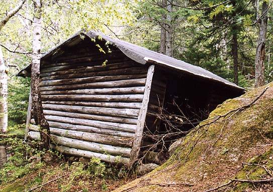
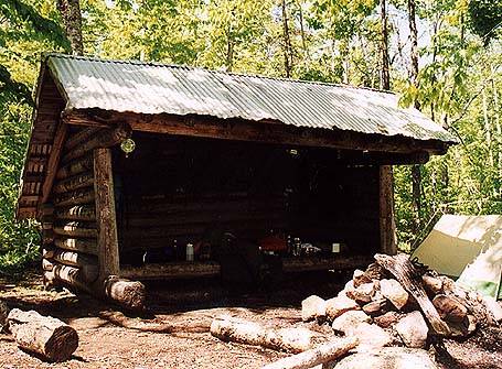
 The next stop was at Resolution Shelter. I met two guys who had set up their hammocks
next to the shelter and were taking a siesta, which seemed like a good idea in the noon
heat. I took a few shots for the website (all my trips have this as a sub-plot), hoisted
my pack back on and headed out. It's a short ways to the col and then a fairly steep climb
to the spur trail for Stairs Mt. Again, this is well worth the effort, as there is an
excellent view south and west, including
of Carrigain. Then it was back on the trail,
headed north on the Davis Path. I knew there were several designated
campsites along
the way, but I didn't know how far I'd get or where I wanted to stay. After hitting the
swampy col between Stairs and Davis, I came across one that just seemed right. Plus I was
hot, tired, and knew that the farther I went the long my trip tomorrow would be. So I
quickly set up camp and hung my food, then grabbed some water and my camera and headed
north again.
The next stop was at Resolution Shelter. I met two guys who had set up their hammocks
next to the shelter and were taking a siesta, which seemed like a good idea in the noon
heat. I took a few shots for the website (all my trips have this as a sub-plot), hoisted
my pack back on and headed out. It's a short ways to the col and then a fairly steep climb
to the spur trail for Stairs Mt. Again, this is well worth the effort, as there is an
excellent view south and west, including
of Carrigain. Then it was back on the trail,
headed north on the Davis Path. I knew there were several designated
campsites along
the way, but I didn't know how far I'd get or where I wanted to stay. After hitting the
swampy col between Stairs and Davis, I came across one that just seemed right. Plus I was
hot, tired, and knew that the farther I went the long my trip tomorrow would be. So I
quickly set up camp and hung my food, then grabbed some water and my camera and headed
north again.
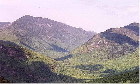
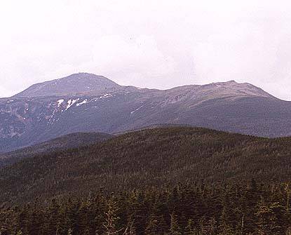
 I was hoping to make it to Isolation, but it didn't happen. When I got to the Davis Path
trail junction I figured that would be as far as I went. It has a better view than Isolation
and it was right there. I had the summit alone, I hadn't seen anyone since I'd left the
campsite, and I just hung out for a while, resting, and absorbing the entire southern
Presidential Range. It's a great view, the whole southern Presie ridge, plus all of
Montalban Ridge, Washington, the Wildcats, and even south. It's a very nice place. After
a bit I headed back, scooping a handful of snow from the one remaining patch to put
under my cap for cooling. Back at the campsite I pulled a quick dinner together, read some
maps for a while to plan for tomorrow, and fell asleep under a rising moon.
I was hoping to make it to Isolation, but it didn't happen. When I got to the Davis Path
trail junction I figured that would be as far as I went. It has a better view than Isolation
and it was right there. I had the summit alone, I hadn't seen anyone since I'd left the
campsite, and I just hung out for a while, resting, and absorbing the entire southern
Presidential Range. It's a great view, the whole southern Presie ridge, plus all of
Montalban Ridge, Washington, the Wildcats, and even south. It's a very nice place. After
a bit I headed back, scooping a handful of snow from the one remaining patch to put
under my cap for cooling. Back at the campsite I pulled a quick dinner together, read some
maps for a while to plan for tomorrow, and fell asleep under a rising moon.
 Sunday I got up early, had a quick oatmeal breakfast, pumped water, and headed out. I got
back to Stairs Mt pretty early, still hadn't seen anyone, and rested a bit. Then down to
the Resolution Junction and up and over Mt Resolution. This would take me to Bartlett, but
I figured I could hitch back to my car. After Resolution, which has some nice views from
the mostly open summit and ledges, the trail drops and then climbs Mt Parker, which also
has a nice open summit but, alas, no water. By the time I hit the Mt Langdon trail junction
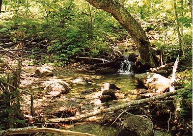
I was dry. I ran up to Langdon Shelter which has a nice stream
water source and must have
drank 2 liters on the spot. By then I was ready to head out, so I just put my head down
and motored out. It was mostly woods roads from there, so it went quickly. The store in
Bartlett was jammed with holiday tourists, so I bought my Gatorade (yum) and hitched a
ride from in front of the store.
Sunday I got up early, had a quick oatmeal breakfast, pumped water, and headed out. I got
back to Stairs Mt pretty early, still hadn't seen anyone, and rested a bit. Then down to
the Resolution Junction and up and over Mt Resolution. This would take me to Bartlett, but
I figured I could hitch back to my car. After Resolution, which has some nice views from
the mostly open summit and ledges, the trail drops and then climbs Mt Parker, which also
has a nice open summit but, alas, no water. By the time I hit the Mt Langdon trail junction
I was dry. I ran up to Langdon Shelter which has a nice stream
water source and must have
drank 2 liters on the spot. By then I was ready to head out, so I just put my head down
and motored out. It was mostly woods roads from there, so it went quickly. The store in
Bartlett was jammed with holiday tourists, so I bought my Gatorade (yum) and hitched a
ride from in front of the store.
All in all, a fun trip. I should have carried more water on the second day, and I kind of
wish I'd pushed on to Isolation, but the views and the solitude were fantastic. Where else
could you hike/camp for Memorial Day and see only 18 people?
Back to White Mountains home page