Liberty/Flume Trip - ??/Aug/97

 In our never-ending quest to get more 4000'ers for the Brenda, Lafe
and Allison we
decided to grab the southern two peaks in the Franconia Ridge. With
two cars we were able to do a straight line trip, which makes these
peaks more interesting. We dropped the first car at Lincoln Woods,
our end point, and drove around to the parking area just north of
the Flume Visitor's Center. It's about 1 mile of hiking parallel to
the highway before you hit the real Liberty Springs trail. Then
we started the real trail. We stopped for a
water break about a mile later, just where
the snow started on my previous trip
up this trail. It gets somewhat steep after that,
but nothing that will kill you.
In our never-ending quest to get more 4000'ers for the Brenda, Lafe
and Allison we
decided to grab the southern two peaks in the Franconia Ridge. With
two cars we were able to do a straight line trip, which makes these
peaks more interesting. We dropped the first car at Lincoln Woods,
our end point, and drove around to the parking area just north of
the Flume Visitor's Center. It's about 1 mile of hiking parallel to
the highway before you hit the real Liberty Springs trail. Then
we started the real trail. We stopped for a
water break about a mile later, just where
the snow started on my previous trip
up this trail. It gets somewhat steep after that,
but nothing that will kill you.
 We made it to Liberty Springs
Campsite about 1.5 hours after we left the cars. Here we
filled up waterbottles for the rest of the
trip. I wandered around the campsite taking
pictures, while back at the view, Lafe and Allsion were taking their own
peculiar brand of photos. Of course, I ran into
someone I know at the campsite, a common occurance these days. From
there it's only .3 miles to the ridge, and .3 more to the summit of
Liberty. The views
into the Notch weren't bad, but the weather was
a little threatening. We lounged a bit before
pushing on to Flume, our next
destination.
We made it to Liberty Springs
Campsite about 1.5 hours after we left the cars. Here we
filled up waterbottles for the rest of the
trip. I wandered around the campsite taking
pictures, while back at the view, Lafe and Allsion were taking their own
peculiar brand of photos. Of course, I ran into
someone I know at the campsite, a common occurance these days. From
there it's only .3 miles to the ridge, and .3 more to the summit of
Liberty. The views
into the Notch weren't bad, but the weather was
a little threatening. We lounged a bit before
pushing on to Flume, our next
destination.
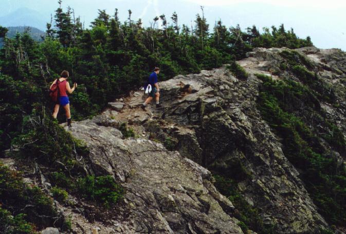
 During the ridge walk to Flume, the clouds started gathering and we
even felt a few sprinkles. I was expecting the worse, but everyone
else was taking a much more relaxed attitude, and besides, we all had
rain gear, extra food, and plenty of daylight. Of course, they were
right and the rain never really came to the southern end of the ridge.
During the ridge walk to Flume, the clouds started gathering and we
even felt a few sprinkles. I was expecting the worse, but everyone
else was taking a much more relaxed attitude, and besides, we all had
rain gear, extra food, and plenty of daylight. Of course, they were
right and the rain never really came to the southern end of the ridge.
 We made it to the summit and then settled down
for lunch. The rest of the ridge was looking a bit
darker than us, but it was all staying north. The
summit of Flume is narrow and rocky but a good
place for a rest, with nice views back to Liberty.
After a bit of silliness we continued on. The
trip down goes south along the ridge, then drops steeply down the Osceo
trail. There are some impressive ladders on the
top sections, and Lafe felt the need to run up and down them a few times
just for fun. The trail keeps descending, swithing back on occasion
following old logging railroad grades for several sections until hitting
the Wilderness trail, a straight flat route out.
A short while later we were at the suspension bridge
that crosses the Pemigewasset River at the
trailhead.
We made it to the summit and then settled down
for lunch. The rest of the ridge was looking a bit
darker than us, but it was all staying north. The
summit of Flume is narrow and rocky but a good
place for a rest, with nice views back to Liberty.
After a bit of silliness we continued on. The
trip down goes south along the ridge, then drops steeply down the Osceo
trail. There are some impressive ladders on the
top sections, and Lafe felt the need to run up and down them a few times
just for fun. The trail keeps descending, swithing back on occasion
following old logging railroad grades for several sections until hitting
the Wilderness trail, a straight flat route out.
A short while later we were at the suspension bridge
that crosses the Pemigewasset River at the
trailhead.
After a brief swim in the Pemi we gathered the cars and hit the Common
Man in Lincoln for a fine meal and reflected on our sore legs. There's
a lot of descent on this trip, steady and steep. After spending the
night at the Moosilauke Ravine Lodge we hiked
up Moosilauke the next day.
Back to White Mountains home page