
The Ridge of the Caps is a lure to all hikers, since it's the highest trailhead in the White Mountains. This lets you climb Mt Jefferson, one of the highest and roughest peaks in the National Forest by climbing only 2700', still a lot but not the 4000' required from most trailheads. We were up for the weekend, staying at a cottage at the Bartlet Inn so we could hike pretty much anything in the northcountry. After a fine breakfast at the inn we packed up and headed to the trailhead over a rough but very passable Jefferson Notch Road, arriving with a number of other folks all planning the same sort of trip. We parked in the small lot on the road, the main lot was mostly full. It looked like it was going to be a good day for hiking, mostly sunny with little wind.
 The start of the trip is a
walk in the woods, with some steady gain of elevation. After a while
we came out at Whirlpool Ledge, so named for the
holes worn into the bare rock by the action of
water over years and years. This is a great spot to look up and get a feel for what the day
held for us. The
views to the north and west show all of the
southern ridges, with some of the summits blocked by
the mountains above us. We met a group of girl scouts, all very excited about their big hike and
rightly so. Back into the woods, where we passed the
trail junction with the Link, a very rough section
of trail that can potentially be used to make a nice loop, except that the trail is pretty miserable.
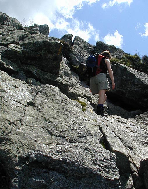
Onward and upward we went, coming out at
treeline and begining the
scrambling. There are some
interesting
sections of this trail, but nothing much worse than any other trail in the Northern Presidentials.
And you can look back and check on your car. We
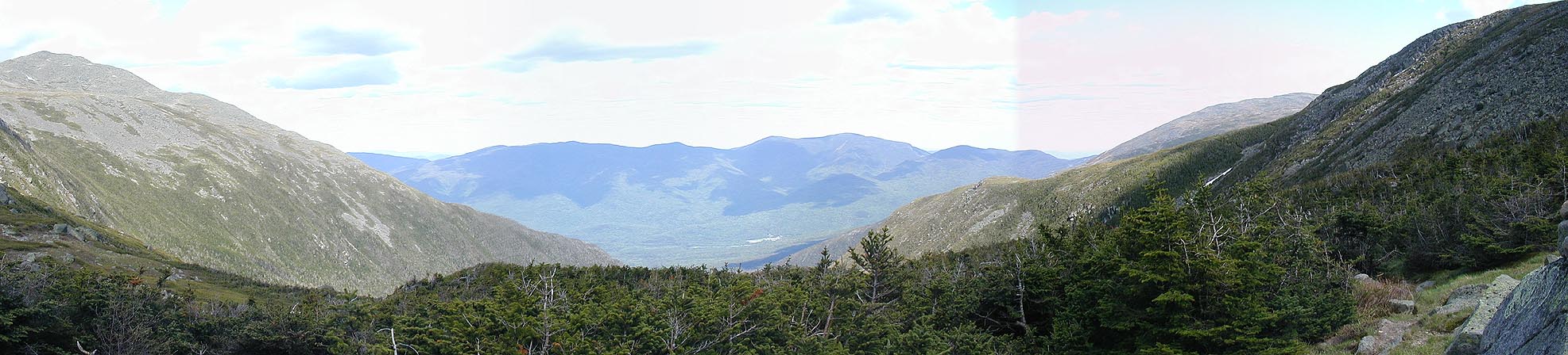
were getting some excellent views of
Washington, Monroe, and the Castellated Ridge, as well as
north to the Pilot Range. Finally we hit the junction with the
Cornice trail, which cuts over from Edmands Col and was our planned route back after looping around
the summit.
The start of the trip is a
walk in the woods, with some steady gain of elevation. After a while
we came out at Whirlpool Ledge, so named for the
holes worn into the bare rock by the action of
water over years and years. This is a great spot to look up and get a feel for what the day
held for us. The
views to the north and west show all of the
southern ridges, with some of the summits blocked by
the mountains above us. We met a group of girl scouts, all very excited about their big hike and
rightly so. Back into the woods, where we passed the
trail junction with the Link, a very rough section
of trail that can potentially be used to make a nice loop, except that the trail is pretty miserable.
Onward and upward we went, coming out at
treeline and begining the
scrambling. There are some
interesting
sections of this trail, but nothing much worse than any other trail in the Northern Presidentials.
And you can look back and check on your car. We
were getting some excellent views of
Washington, Monroe, and the Castellated Ridge, as well as
north to the Pilot Range. Finally we hit the junction with the
Cornice trail, which cuts over from Edmands Col and was our planned route back after looping around
the summit.
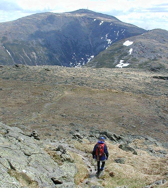
 From the junction to the summit is basically rock hopping, lots of rock hopping. But once you're
above treeline like that you don't notice it so much. We topped out at the summit where a dozen or
so folks were hanging out enjoying the views (movie). There were some clouds out, which made the view not
quite perfect, but I don't believe I heard anyone complaining. One of my favorite places is
Montecello
Lawn, between the summit and the Great Gulf, so we had planned to go down the Jefferson Loop to the
Gulfside trail and follow that back to Edmands Col, then take the Cornice trail back to Ridge of
the Caps. The drop down from the summit is quick enough and passed by some lovely flowers just coming
into bloom. Once on the Gulfside trail, it's like a walk in the park. I love the feeling of travel
above treeline on easy terrain with views all around. Eventually you stop looking at the distant views
and see things that are up close. It's a wonderful part of the
journey (movie).
From the junction to the summit is basically rock hopping, lots of rock hopping. But once you're
above treeline like that you don't notice it so much. We topped out at the summit where a dozen or
so folks were hanging out enjoying the views (movie). There were some clouds out, which made the view not
quite perfect, but I don't believe I heard anyone complaining. One of my favorite places is
Montecello
Lawn, between the summit and the Great Gulf, so we had planned to go down the Jefferson Loop to the
Gulfside trail and follow that back to Edmands Col, then take the Cornice trail back to Ridge of
the Caps. The drop down from the summit is quick enough and passed by some lovely flowers just coming
into bloom. Once on the Gulfside trail, it's like a walk in the park. I love the feeling of travel
above treeline on easy terrain with views all around. Eventually you stop looking at the distant views
and see things that are up close. It's a wonderful part of the
journey (movie).


On the way around to Edmands Col we came across a large snow patch, still holding on quite well into June. We took turns boot skiing the slope, reliving the past ski season. It was a nice combination of activities, a hot early summer hike with boot skiing. Eventually we decided to push on towards Adams, past the junction with the Six Husbands trail and the other end of the Jefferson Loop. There we came to the other snow field, the one that is usually the last to melt. It was quite thick, probably close to 10 feet in places, and had a nasty lip that you wouldn't want to slip off. We decided not to boot ski here. There are a few steep sections on the last portion down to the col, but aside from offering excellent photo opportunities, it's an easy trip. In the col we headed over to the spring which is located just inside the Wilderness Area on the Edmands Col Cut-Off. Just a few feet off the main trail you can get some quiet and a slightly different view. And rinse your face off, a welcome relief on a hot sunny day.


After going through the col we hooked up with the Cornice trail for what was to be the most difficult and painful part of the journey. Although there are excellent views, especially of the Castellated Ridge the footing is just awful, and we were tired enough for it to make a difference. We finally made it back to Ridge of the Caps and ate our remaining food and drank most of our remaining water. We were beat, and now had to descend back to the car. Just as we were ready to head out a hawk or falcon of some sort dove past us, headed down towards Whirlpool Ledge, covering the remaining part of our hike in about 20 seconds. I wished I could fly right about then. There was someone resting on the Ledge when we got there, and someone joined us on his very fast descent, the only two people we'd seen in the last hour or so. From there the trip to the trailhead was quick, and we were very happy to be back in the car and cruising back to the Inn.
 After a fine dinner at the Red Parka Pub we planned the following day hike. Since we were pretty beat up
from Jefferson we chose what we thought would be a nice short dayhike, Frankenstein Cliffs and Arethusa
Falls. The hike up to the cliffs is fun, taking you under the big trestle then climbing fairly steeply
to the view. It's a similar view of Crawford Notch as from Willard or Avalon, but much further down the
notch. Soon after leaving the ledge we came across a bunch of
Lady Slippers, pretty rare to find in the
woods like that. The rest of the hike is pretty mellow, going up and down, eventually hitting the Falls.
We were pretty spent by then, the hike being a bit longer than we had planned and we could still feel
yesterday's hike. The water felt cool and the falls were
running well (movie). It's all downhill from there, and
we were pleasantly surprised to find a small shop run at the trailhead selling ice cream. What a fine way
to end a hike!
After a fine dinner at the Red Parka Pub we planned the following day hike. Since we were pretty beat up
from Jefferson we chose what we thought would be a nice short dayhike, Frankenstein Cliffs and Arethusa
Falls. The hike up to the cliffs is fun, taking you under the big trestle then climbing fairly steeply
to the view. It's a similar view of Crawford Notch as from Willard or Avalon, but much further down the
notch. Soon after leaving the ledge we came across a bunch of
Lady Slippers, pretty rare to find in the
woods like that. The rest of the hike is pretty mellow, going up and down, eventually hitting the Falls.
We were pretty spent by then, the hike being a bit longer than we had planned and we could still feel
yesterday's hike. The water felt cool and the falls were
running well (movie). It's all downhill from there, and
we were pleasantly surprised to find a small shop run at the trailhead selling ice cream. What a fine way
to end a hike!